Research Funding cycle: 2016-21
Items of work carried out under the 2016-21 funding cycle
River Leven Catchment Initiative: Synthesis of current knowledge to help identify environmental management priorities to improve the water environment

The main aim of the study was to review and synthesise current knowledge relating to the water environment within the River Leven catchment, including the condition of its rivers, lochs and groundwater.
The study addressed six main research questions.
- What is the current condition of all rivers, lochs and ground waters in the River Leven catchment, based on available information?
- What are the main pressures on the aquatic environment and the sources of those pressures?
- What are the environmental management priorities for improving the water environment?
- What is the baseline socio-economic condition of the River Leven catchment?
- What is the current condition of Loch Leven and its catchment, and how have improvements supported socio-economic development?
- What are the gaps in evidence and how can they be addressed?
All available water quality, hydromorphological and ecological data for the River Leven catchment were reviewed to identify water bodies that fail to meet Water Framework Directive (WFD) and conservation targets and could be improved through targeted management interventions. In addition, SIMD data were used to identify areas where high deprivation coincided with areas where water quality improvements are required to meet WFD and conservation objectives. The results are presented as maps and tables.
The output from this project provides a “first-pass” assessment of understanding of the River Leven catchment. It is not intended to be a comprehensive review of all of the data and information available. Draft environmental priorities are suggested for further consideration.
Integrated Water Resource Management in Southern Malawi - Enhancement report for project expansion

Abertay University was commissioned by the Scottish Government through Hydro Nation International to explore ways to enhance the impact of Scottish Government support to the Government
of Malawi in the achievement of Sustainable Development Goal 6 (SDG6). The project involved:
- A review of the changing demand on water supplies, the impact of abstraction and the resilience and sustainability of ground water in Malawi
- Engagement with key stakeholders in water development in Malawi to map and understand the complex interaction of key water stakeholders
- The development a roadmap for scaling up Scottish Government support to meet the SDG6
- The establishment of enhancement indicators to support planning and monitoring of a future roll-out of Scottish Government SDG activities across Malawi.
The review of knowledge of sustainable water resources in Malawi showed that there is a general reduction in available water resources resulting in significant lowering of surface and groundwater levels. Large-scale deforestation alongside reduced frequency of precipitation and higher ambient temperatures, and increased water demand associated with high population growth rate are believed to be some of the factors affecting the water levels. Hence, a holistic assessment of water supply and demand, i.e., integrated water resources management implementation, is needed to address medium to long-term water availability challenges.
The Stakeholder Map provides a representation of the water sector in Malawi showing stakeholders in relation to their contribution to key areas of governance and policy development, regulation, policy implementation and service provision. The representation shows the diverse range of actors resulting in a complex interaction amongst stakeholders. It highlights the complexity of the planning and co-ordination processes and a need for enhanced coordination of activities in the sector. It was found that the nature of these processes limits the effectiveness of the planning process, which in turn restricts the effective operation of the water sector and the implementation of water development projects.
The Critical Path will assist Scottish Government to identify and develop suitable interventions actions to support the water sector in Malawi. It identifies 5 key challenges for Malawi, namely; coordination and governance, water resource management, infrastructure, capacity building and monitoring and surveillance. The following key interventions have identified from the Critical Path to help address these challenges.
- Scottish Government (Role as a donor) - Support coordination efforts at Donor and NGO groups (Donor Group/Sector Working Group/WESNET).
- Scottish Government – Raising the profile of water and improving the governance and regulatory framework (Government – Government interaction).
- Scottish Government - Support local training provision and capacity building
- Scottish Water International - Support asset assessment and management plans
- Scottish Environment Protection Agency (SEPA) - Catchment management and water resources management support.
Enhancement Indicators have been established to aid planning and monitoring of future Scottish Government support activities in Malawi. Planned support activities can be designed using a delivery framework, the identified deliverables mapped to relevant indicators and a qualitative assessment made of the extent of their contributions of the activities to the indicators. An appropriate sub-set of indicators can then be developed into metrics for ongoing monitoring.
Overall, this study provides tools and templates for assessing and developing effective interventions to address SDG6 needs in sub-Saharan African countries.
Risks to private water supplies from the presence of per- and polyfluoroalkyl substances (PFAS)

In Scotland and the EU, drinking water quality is regulated under the Council Directive 98/83/EC on the quality of water intended for human consumption (Drinking Water Directive-DWD). The revision of Annex II Part C to the DWD in October 2015 focussed attention and limited resources to hazards of local concern, by requiring risk assessments at a supply zone scale as a basis for granting deviations from the list of parameters and frequencies subject to compliance monitoring. On the 1st of February 2018, the European Commission adopted a proposal for “recasting” the DWD to improve the quality of drinking water and provide greater access and information to citizens (EU Recommendation 2018). The proposal updates the list and standards (i.e. parametric values) of parameters to be monitored in line with latest recommendations of the World Health Organisation (WHO 2017).
The update includes chemicals, which are “new” to the Directive (EU Recommendation 2018), such as:
- Per- and polyfluoroalkyl substances (PFAS) as a group.
- Individual PFAS, e.g.: perfluorooctane sulfonic acid(PFOS), perfluorooctanoic acid (PFOA), perfluorobutane sulfonic acid (PFBS), perfluorohexane sulfonic acid (PFHxS), 8:2 flurotelomer alcohol (8:2 FTOH), 6:2 flurotelomer sulfonic acid (6:2 FTSA), perfluorobutyric acid (PFBA), perfluoropentanoic acid (PFPeA), perfluorohexanoic acid (PFHxA), perfluoroheptanoic acid (PFHpA), perfluorononanoic acid (PFNA), perfluorodecanoic acid (PFDA) and many more.
It is in this context that the present report was produced, addressing specifically the question:
Is there sufficient evidence for a high-level, national-scale assessment of the risk of detecting per- and polyfluoroalkyl substances (PFAS), such as perfluorooctane sulfonate (PFOS) and perfluorooctanic acid (PFOA), in private water supplies (PWS)?
This project developed and implemented a risk-mapping method based on GIS tools, a review of available evidence on types of direct PFAS sources (i.e. related to manufacturing and use) to the water environment in Scotland, the UK and internationally, and on available PFAS data in Scotland. We showed that there is sufficient evidence to identify the locations of the majority of types of potential direct PFAS sources (hereafter reported as Potential PFAS Source Sites) in relation to the locations of all PWS. However, there is not sufficient open-access PFAS data to identify PFAS risk to PWS, i.e. whether and where PFAS concentrations are above the limit of detection (LOD) in drinking water sources to PWS.
Topo-bathymetric LiDAR in support of hydromorphological assessment, river restoration and flood risk management

This project evaluated topo-bathymetric LiDAR* data for the Rivers Dee and Garry by assessing performance in terms of:
- accuracy
- spatial resolution (point density)
- completeness of data and
- measurement of water depth.
The research also considered aspects relating to the quality of the provided datasets. This report discusses the outcomes of these investigations and discusses factors influencing the 2 results. In addition, consideration is given to the potential
of topo-bathymetric LiDAR for classifying river typology, characterising hydromorphology and for supporting hydrodynamic modelling applications. These are criticalactivities in terms of water body condition assessment and management. The specific research questions that this report responds to are:
- What are the strengths and limitations of topo-bathymetric LiDAR?
- Can this technology be used to improve river typology classification?
- Is it possible to derive detailed hydromorphological assessments?
- What is the potential for supporting 2D hydrodynamic modelling?
The main findings presented in this study can be summarized as follows:
- Topo-bathymetric LiDAR worked well for the River Dee where near-complete coverage of the river bed and good coverage of the water surface were achieved. This is likely due to good bed reflectance (gravel bed), combined with favourable water clarity. Due to very low flow conditions at the River Garry, performance was limited. This reinforces the need to evaluate likely success at potential sites prior to survey commission.
- Topo-bathymetric LiDAR was found to offer a similar accuracy and precision to conventional topographic LiDAR, with a mean discrepancy of 0.04 m. The mean error of the water surface and bed points was between 0.04 and 0.07 m.
- Topo-bathymetric LiDAR can provide good coverage of the river bed. For the River Dee, >95 % of the river bed was captured. The measured spatial resolution (point density) of bed points here is 15 points/m (single flightline). This is very similar to the spatial resolution of points over dry terrain.
- Use of a single green laser produces relatively few returns from the water surface compared to the river bed, and the coverage of water surface returns is highly variable. Automated identification of water surface points is still very challenging, particularly for complex topography (e.g. River Garry), but is important in order to enable refraction correction. This is one of the current limiting aspects to a more automated and reliable workflow.
- Depths shallower than approximately 8 cm cannot be measured because the signals from the water surface and river bed cannot be distinguished. This is a fundamental limitation of most commercial LiDAR systems. The Riegl VQ-880-G instrument used here has been designed with a very short laser pulse duration to minimise this effect.
- Topo-bathymetric LiDAR can contribute to various river management tasks including assessment of existing morphological typology and identification of hydromorphological features. While this was assessed here in a theoretical manner, it should be achievable through basic interrogation of LiDAR data in combination with expert hydromorphological input. More automated classification is feasible, but the effort required to reliably achieve this should not be underestimated.
- Topo-bathymetric LiDAR offers potential to enhance hydrodynamic models – e.g. for flood risk and mesohabitat modelling. Such models currently rely on field surveyed cross-section data (or approximations) to represent the channel. Provision of a combined channel and floodplain DEM will allow models to be parameterised with more reliable and continuous topographic information.
- It is challenging to coordinate topo-bathymetric LiDAR surveys with ‘ideal’ flow conditions. Flows which are too too low will cause difficulties due to very shallow depths (e.g. River Garry). Conversely, higher flows may produce more turbulent conditions, which present challenges for capturing the water surface and possibly also the bed. ‘Average’ flow conditions (e.g. Q50 discharge) are most conducive to successful capture.
*LiDAR is a surveying method which is often used to create high-resolution maps. It measures distance to a target by illuminating the target with pulsed laser light and measuring the reflected pulses with a sensor
Key barriers to the adoption of innovation in water and wastewater service provision

The aim of the research was to identify barriers faced by private developers in the provision of innovations in water and wastewater services and to provide recommendations to enhance innovation in building and managing water and wastewater assets. In order to achieve this aim, the project team carried out a detailed literature review using data and information sourced from academic and grey literature to identify barriers to adoption of innovation in water and wastewater service provision. This was
accompanied by collection and review of information obtained from key stakeholders and developers. Scottish Water guidance documents provided to developers were reviewed to identify where barriers to innovation may exist within the guidance. A survey of developers was carried out to gain direct feedback from private sector actors on barriers to innovation. A meeting with the Scottish Water asset vesting team was held to discuss any key issues.
The literature finds that the drivers for the adoption of innovation in water and wastewater services are typically top town (regulator or utility drivers) or bottom up (community or consumer driven), whereas the developers or private sector supply chain typically takes a conservative approach to innovation. The reasons for this can be linked to the barriers to adoption of innovation in water and wastewater services, largely applicable across the construction sector.
These barriers include:
- Lack of internal/external financial resources to fund innovations
- Lack of human resources to navigate innovation landscape, including certification and approvals processes
- Lack of financial incentive to innovate, benefits are transferred to end user
- Risk-averse behaviours, technology risks associated with water quality and public health
- Procurement systems and regulatory environment that limit the market for innovations
The review has also identified recommendations for overcoming some of these key barriers in order to increase the uptake of innovation by private developers across the water sector. This includes encouraging organisations to strategically plan for innovation, building up internal capacity, and leveraging support of external stakeholders such as the utility. The utility will be a primary beneficiary of innovation particularly for technological solutions that extend the lifespan of infrastructure and improve quality of service provision. Therefore, utilities have a major role to play in supporting private sector actors to engage in innovation. This could be assisted by closer direct working in the innovation process, including greater knowledge sharing
and collaborative practices, or improved procurement systems that do not discourage innovation. Collaboration would also include the shared use of enabling technologies and sharing data (e.g. sensors and monitoring, use of visualisation and modelling techniques) that can help to reduce elements of risk within the innovation process.
The drive to improve water and wastewater service provision in remote areas, provides challenges to both utilities and private sector developers. Literature indicates that there is a trend towards remunicipalisation of decentralised systems elsewhere, as a result of poor technology performance or service provision. Innovative approaches and technologies could assist in overcoming some of these issues, but to be effective will require a more collaborative approach. In prioritising innovation with regards to small water and wastewater systems, enabling factors can include prioritising the market (e.g. focus on unserviced areas), government or utility support to overcome financial barriers and help to align value and risk chains, involvement of the utility in technology selection within the planning framework, and engagement with communities to raise awareness and educate end users on the capabilities and risks of technology choices. Innovation champions across stakeholder groups can be important to driving change, providing support, and ensuring collaborative approaches are adopted.
Lead in drinking water: public health, mitigation and economic perspectives
 and The James Hutton Institute")
Lead pipes and plumbing components such as lead-solder and brass fittings can contaminate drinking water on its route from the water mains to the premises and pose a public health risk. Exposure to lead in tap water is entirely preventable but challenging to achieve. To contribute to a better understanding of these challenges, this report reviews evidence on the public health, mitigation and economic perspectives of lead in drinking water in Scotland and internationally. The main document is supported by an extensive literature review in the Appendix detailing evidence on lead sources and health effects in Scotland and internationally, factors influencing lead levels in drinking water, and the water lead-blood lead relationship.
Impacts of winter 2015/2016 flooding in and around Ballater and in the Garioch: Project Year 2 Summary
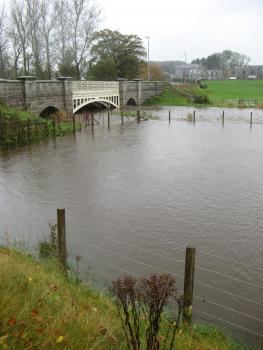
The purpose of the Assessing the Long-term Impacts of Flooding on People and Communities project is to better understand the long-term impacts of flooding upon people and communities and to consider what types of support and advice people and communities need at different stages of a long-term recovery. Over a 36 month period, the project is advancing our understanding of these long-term impacts, contributes to better flood risk management and makes suggestions as to how personal and community resilience may be supported and enhanced.
Two communities in Aberdeenshire affected by flooding in December 2015/ January 2016 are the focus of the research, one of which has repeatedly experienced flooding, one of which had little prior experience of flooding. The Ballater area, in upper Deeside, experienced severe flooding for the first time in many years in late December 2015, flooding that was largely unexpected and which had a widespread impact on the community. The Garioch area, specifically Port Elphinstone and Kintore, on the River Don, has experienced many flood events and was badly flooded in early January 2016. In Year One of the project three distinct yet complimentary data collections elements were undertaken: a Household Survey, conducted in both case study areas; a Business Survey, conducted in both case study areas; and interviews with residents and business owners/ managers in both case study areas, including interviews with those who were and were not directly affected by the Winter 2015/16 flooding. Findings from these three elements of data collection were presented, in three separate reports, to the project Steering Group in late 2017. A short report summarising Year One activities and key findings was published by CREW in early 2018. In Project Year Two a second round of interviews were conducted with householders and business owners/ managers in Ballater and Garioch. This report presents an overview of findings from the Project Year Two interviews. Another report will follow at the end of the 36 month project period.
You can find the first report of this project here
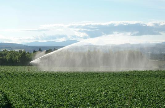
Water and the circular economy - where is the greatest sustainable economic benefit for resource recovery in the water environment?

This project set out to answer three research questions:
- which resources can be, in principle, recovered or obtained from water in Scotland;
- what is the total amount of each resource that is present in, or can be obtained from, different water sources in Scotland, and;
- which maximum market value and potential savings in energy and carbon dioxide emissions could be achieved when assuming 100% recovery of each resource.
In this project, researchers calculated the amount of each resource (N, P, K, Mg, Ca, Fe, heat, methane and hydrogen) which is present or can be obtained from raw waters or wastewaters in Scotland, their economic value and the maximum potential savings in energy and carbon dioxide emissions associated with the recovery of these resources. The technology readiness level (TRL) of the processes needed for the recovery of these resources was also estimated, and recommendations are provided in the report for future investigations.
Source Control SUDS in Scotland
This project looks at various aspects of source control SUDS in Scotland and globally. The following publications are part of this project:
- Research Summary: Implementation of Source Control SUDS in Scotland.
- A rapid review of the background to source control.
- Source control SUDS delivery on a global scale and in Scotland including approach by responsible organisations and professional groups.
- Appendices
A review of the arguments relating to bulk export of water
This document reviews the available information on water export and summarises the arguments for and against, providing examples where possible.There is very limited, up-to-date robust and impartial evidence relating to bulk export of water, consequently much of the information presented here is International in its nature.
